|
Produced by the Glenholm Wildlife Project Part-funded by Making Tracks South of Scotland Nature Based Tourism Project |
|
Glenholm Wildlife - The Marches |

|
Farm Etiquette
When walking in Glenholm please observe the following guidelines:
¨ Leave gates as you find them ¨ Keep dogs on leads when near livestock ¨ Do not walk near sheep with dogs during March, April and May when lambing is in progress. ¨ Never take dogs into fields containing cows ¨ Avoid fields that contain cows with young calves ¨ Avoid walking directly across cultivated fields
¨ Take your litter home with you ¨ Avoid picking any wild flowers ¨ Keep clear of the farm steading and all farm machinery ¨ Avoid walking through private gardens
Please note that visitors to Glenholm explore the area at their own risk. Where possible please follow the routes which have been waymarked for you and if you see anything that concerns you please take no direct action but notify the Glenholm Centre as soon as possible. |
|
Approximate Total Length: 9¾ Kms
Terrain: Moderate to Difficult - one steep down slope on Preston Hill; one steepish slope up to the Fort; may be wet in some areas; the first half of the walk can be particularly wet in some areas; this first half is also less suitable for walkers with dogs as two stiles do not have adjacent gates and many of the fields in this area are used for cattle. |
|
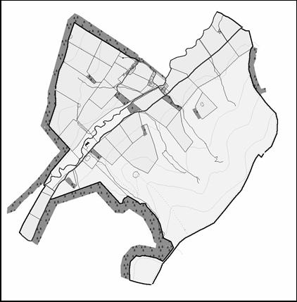
Directions: From the Centre walk down the road towards the farm steading crossing the Holms Water river. Please keep to the road as you pass the Steading (13) and in front of the bungalow (Glendene) and continue on the road with the trees on your right and the field on your left. At the top of the hill follow the road round to the left in front of the Cedar bungalow and up to Cardon Farmhouse (14). At this point your route turns right and through the gate into a field. Once in the field turn immediately left and when you reach the boundary fence of this field turn right and follow the fence right to the top of the hill, which coincidentally is the farm boundary (15). At the top of the hill a very short detour to your right allows you to see the remaining evidence of an Iron Age fort. The path however turns left crossing a stile and following the farm boundary past 16, across to Preston Hill (17) and steeply down the side of Glenhighton forestry. At the bottom of the hill (18) the waymarked route leads you along the side of the Holms Water river to the boundary fence with Glenhighton. Cross this fence and turn left across the road bridge over the river and then follow the road back down the glen towards Glenholm. After passing the Iron Age settlement ring on your right, your route turns right (4) and onto the hill. Having left the road your path crosses back over the burn and along the right side of Fiona’s wood. |

|
Hide & Pond |
|
Chester Rig Fort (333m) |
|
Fiona’s Wood |
|
You can buy booklets about the wildlife, agriculture and archaeology of the glen, farm and wildlife identification sheets, as well as a range of wildlife related goodies from the Glenholm Shop. |
|
334m |
|
220m |
|
442m |
|
448m |
|
542m |
|
Crossing over the stile (5) waymarking posts lead you initially along the side of the fence and then along the valley side. About 400 metres up this gully the path turns back on itself (6) and a steep track to the left takes you up to the Chester Rig Fort (7). From the Fort follow the way markers up the ridge to Chester Rig Head and the dyke marking the farm boundary (8). At this point you may make a short but steep detour up to the summit of Blakehope Head and back. To get to the summit you have to cross a stile with no accompanying gate. From Chester Rig Head, the route follows the farm boundary across Wrae Hill (9 and 10) as far as the bottom corner of the wood (11). At the corner turn left. We strongly recommend that you do not take a short cut across this corner as the terrain to the left can be very wet and boggy. After crossing the Glenachen Burn, follow the fence on your right until you reach the gate through the dry stane dyke into the School Brae (12). Go through this gate and down the side of the School Brae field back to the Glenholm Centre. If you are walking with dogs please check that there are no cattle in the field and that your dogs are under control before entering this field.
|
|
Fort |
|
Preston Hill |
|
Chester Rig Head |
|
Blakehope Head |
|
School Brae |
|
Wrae Hill |